Name
Khorheh خورهه
Historical Period
Parthian/Sasanian
History and Description:
The archaeological site lies at an altitude of 1200 m, in a plain bordered by mountains. The plain is irrigated by the seasonal Qomrud river that rises in the Golpāyegān mountains. The most distinctive aspect of the site is two tall standing columns in stone with their Ionic capitals often mentioned in historical records (fig. 1). The earliest description of the ruins is by Hasan Qomi, the author of Tārikh-e Qom, written in 378 H./988 A.D., who attributes its foundation to Alexander and refers to its stone structures (Tārikh-e Qom, p. 69):
Khorheh and its monument were built by Alexander and at that place, there are four columns, circular and similar in size, with no imperfection and disproportion. The columns seem to be so polished as if they were in one piece. It is said that they were formerly surmounted by a qobeh in stone, which is now fallen.
Qomi’s short description of the columns capped with a qobeh has been a matter of much debate among visitors and scholars who attempted to see or identify a domed monument (see below). The site does not seem to be mentioned in other medieval sources. Located off the main Qom – Isfahan road, Khorheh hardly appears in travelers’ accounts with the exception of Edward Stack of the Bengal Civil Service who traveled in Persia during 1881. Stack briefly visited the ruins and noticed Naser al-Din Shah’s excavations (see below) as he wrote (Stack, Six Months in Persia, vol. 2, pp. 129-130):
As we drew near Khurha, we passed two stone pillars with capitals that seemed Ionic. I visited them in the afternoon. They were part of a colonnade or roofed building supported on pillars. The people say there used to be fourteen pair; their height is about twenty-five feet, and they are composed of cylinders of stone some four feet long. The stone seemed to be a hard kind of limestone. The capitals are Ionic but adorned on two sides with horizontal dice boxes of stone, or rolls tied tightly in the middle. Remains of a fort of unhewn stone stand close by. As usual, the people were as ignorant as myself of the history of these relics; but it seemed to be a fact that the Shah had encamped here some twelve years ago, had overset a number of the pillars, and had broken up the stone flooring of the colonnade, in the vain hope of finding treasures.
Archaeological Exploration:
The ruins caught Naser al-Din Shah’s attention during his journey to Qom, Kurdistan, Sultaniyeh, and Azerbaijan in the summer of 1859. A series of photographs were taken during that trip, of which two have so far survived (Adle, “Khorheh,” pls. 3-4). There is also a pencil drawing of the two standing columns probably by Nasser al-Din Shah himself (Adle, “Khorheh,” pl. 2). The album was prepared and presented to him on the 20th of March, 1860, on the occasion of Nowruz. The album is preserved in the Golestan Palace in Tehran. The Shah’s company hired eleven workers to undertake a limited excavation in the area where the columns stood. There is no report of this first excavation at Khorheh. It is remarkable that Naser al-Din Shah, who was passionate about photography and ancient remains, used photography in the service of archaeology by supporting the first Iranian excavation at Khorheh, where the work in progress was documented with photographs. The archaeological expedition at Khorheh is probably the earliest excavation for which photography was used to record the finds. Naser al-Din Shah’s second campaign of excavation at Khorheh began on May 31st, 1892, after an interval of 33 years, during his trip to central Iran. Still perplexed by the presence of the columns, he ordered a team to be formed to study the columns. He recorded this in his diary (published in Adle, “Khorheh,” p. 13, English text):
While we were in Mahallāt, we dispatched Hossein Khān, Officer of the Royal Household and son of Ebrāhim Khān Sadiq-e Khalvat, together with a photographer and Āref Khān, the Translator of Ottoman Turkish, who is accompanying E‘temād-os- Saltaneh, to Khorheh to make photographs of the ancient columns there as well as the village and its gardens.
The second mission to Khorheh lasted for about three days. Mohammad Hasan Khān E’temād al-Saltaneh, the Minister of Publications and Director of the Translation Department, was charged by the king to send a group of photographers to the site. It does not seem that he took the initiative as he wrote in his diary: “… yesterday I sent Afandi [Āref Khān] to Khorheh and he has not come back yet.” (Mohammad Hasan Khān E’temād al-Saltaneh, Ruznāmeh-ye Khāterāt, edited by I. Afshār, Tehran, 1966, p. 932; Adle, “Khorheh,” p. 234). The second expedition team consisted of four individuals, who arrived at the site on May 31st 1892, including Agha Yusef, one of the Shah’s personal photographer. In his photographic survey of the ruins, Agha Yusef shows his skill by placing a standing man to show the scale. Aref Khān, another member of the team, was in charge of drafting a report (Adle, “Khorheh”, p. 13, English text). Finally, Dr. Jean-Baptiste Feuvrier, Nāṣer-al-Dīn Shah’s personal physician, examined the skeletal remains. He refers to the Greeks in connection with the remains at Khorheh (perhaps because of the column capitals in Ionic style), but follows E’temad al-Saltaneh’s opinion on the skeletal remains (Feuvrier, Trois ans à la cour de Perse, p. 367):
Le prince Manoutchcr Mirza profite de notre séjour à Mahalat pour aller visiter les ruines de Khorhé, accompagné de Mirza Floughi [Forūghi], secrétaire d'Etemad es Saltaneh. Ils n'ont trouvé que peu de choses comme restes de constructions; mais, tout près d'une sorte de pilier carré, fortement rongé à sa base, ils ont fait des fouilles et sont tombés sur quantité d'ossements humains, emplissant ce qui leur a paru être un grand bassin, dont ils ont reconnu les briques des bords. Ne serait-il pas plutôt, cet espace fermé plein d'ossements, un de ces sarcophages en briques non cuites comme les Grecs en ont fait pour ensevelir les morts après une bataille? Quoi qu'il en soit, Mirza Floughi me rapporte de là un crâne en assez bon étal et huit pointes de flèche en bronze ou en cuivre. Ce crâne, il faut le dire, ressemble plus à un crâne turc qu'à tout autre, ce qui justifierait l'opinion d'Etemad es Saltaneh, qui pense que cet ossuaire date de l’époque où les Turcs ont converti les Persans par la force à l'islamisme ; car, venus d'Arabie, ils ont pénétré en Perse par ici et ont eu à livrer des combats précisément dans ces régions.
At all events, better photographs were taken from the ruins during the second campaign of excavations (figs. 2 and 3). The archaeological expedition at Khorheh is probably the earliest excavation for which photography was used to record the finds. It thus preceded the use of this technology in archaeology by the Austrians at Samothrace in 1875. The Shah’s two photographic expeditions to Khorheh and his excavations remained unknown until the late 1990s when Chahryar Adle discovered the album of photographs and published them in 2000. The Shah’s photographic expeditions reveal the situation of the site 150 years ago with an open area in front of the colonnaded portico (fig. 4). Besides, a flat mound behind the columns can be seen on the photographs, the upper layers of which were unfortunately removed in the Shah’s hasty uncovering of the monument. Adle points out difficulties in matching Qomi’s description with the physical remains at the site as he writes (Adle, “Khorheh,” pp. 11-12, English text):
Regrettably, these photographs do not help to explain Hassan Qomi’s description of Khorheh. …Thus, it is not clear what Qomi means by the “four pavilions” he refers to; if these four buildings did exist, as mentioned in Tārikh-e Qom (The History of Qom), and if their dimensions were as quoted therein, where were they located and how did they fit into the map presented by Mr. Rahbar? (his fig. 82). The features of this building — pavilion or temple — remain unknown, although the existence of such a construction near mineral springs Takht-e Soleymān on a smaller scale, and one can imagine the existence of an ensemble combining a palace and a temple on this site.
A careful reading of Qomi’s description reveals that he explicitly refers to “four columns” and not to a “four-pavilion” building. Even the debate on the existence of a dome or the like is hopeless because what is mentioned in his text as qobbeh that once caped the columns could simply mean column capitals (Tārikh-e Qom, p. 69). Comparison with the fire temple at Takht-e Suleiman, some 500 km north-west of Khorheh in Iranian Azarbaijan, seems unfounded here given the absence of any archaeological evidence for a Sasanian occupation of the site. Yet, the nearby Imāmzādeh dedicated to a triad of saints (Shahzadeh Abolqāsem, Shahzadeh Eshāq, and Hakimeh Khātun), with its polygonal plan, evokes the “four-pavilion” building.
As early as 1920, Ernst Herzfeld wrote that the “temple at Khorheh” was a Seleucid monument and published two photographs of the columns owned by Friedrich Sarre, in his Am Tor von Asien (p. 32, pls. XVII). Based on the photographs he assumed that there were never more than those two stone columns that formed a temple in antis, the walls of which were in mud-brick and stone. In October 1923, Herzfeld visited Khorheh for the first time and thought that the column bases could be Achaemenid re-used in a Seleucid temple as he wrote in his Reisebericht (pp. 235-236):
Von Kum aus ging ich am 8. Oktober 1923 nach dem Distrikt Mahallāt, wo ich in dem Orte Khurha die Ruinen eines griechischen Tempels vermutete, die Hotum Schindler in seinem Irāq Ajamī erwähnt, und von denen ich früher durch Sarre’s Güte eine Photographie, ohne Ortsangabe und von unbekanntem Urheber , benutzen konnte. Die Ver mutung bestätigte sich. Der Tempel ist der von Khurha. Die Photographie ist wahrscheinlich bei Gelegenheit einer Anwesen heit Nāsir al-dīn Shāhs vor vielen Jahren aufgenommen. Das Tal von Khurha ist sehr schön, voller Weingärten. Schon in der Umgegend fielen mir Stellen alter Siedlungen mit einer Keramik auf, die noch Anzeichen besitzt, die ich später als achämenidisch bestimmen konnte , die aber doch schon der hellenistischen Zeit angehört . Dieselbe Keramik, zusammen mit bronzenen und eisernen Pfeilspitzen etc. findet sich in Khurha selbst auf der Südseite des Flußbettes. Der Tempel liegt am Westende der Weinberge des Ortchens, auf dem Nord ufer Entgegen meiner früheren Vermutung ergab die genaje Geländeaufnahme und einige Schürfungen, daß das stehende Säulenpaar nicht der Tempelfront, sondern der Ecke des Peri bolos angehört, während der Tempel selbst unter einem hohen Schutthügel begraben liegt. Eine Anzahl weiterer Säulenbasen und Kapitäle und Stücke vom Gebälk kamen zu Tage. An die eine Ecke des Peribolos schließt sich ein Hügelgebiet, das yoll war von Scherben großer Pithoi, und dies zusammen mit dem Weinbau des Tales läßt mich vermuten, daß es sich um einen dem Dionysos oder einer seiner Erscheinungen geweihten Tempel handelt. Keramik und Architektur - die Basen sind noch achämenidisch, wie in Pasargadä und an den Königs gräbern, während die Kapitelle orientalisch entstellte ionische sind, weisen den Bau m. E . noch in die seleukidische Zeit, in die vielleicht auch die Gründung des großen Tempels von Kangawar zu setzen ist, der jedenfalls um die Wende unserer Zeitrechnung, nach Isidoros von Charax, schon bestand.
In his later writings, Herzfeld confirms that Khorheh was a temple of Dionysus built on stylobates with a peristyle colonnade bordering a central shrine (Archaeological History of Iran, pp. 51-52). He published better photographs and a general map of the site in his Iran in the Ancient East (figs. 5, 6, 7, 8), where he contemptuously wrote about the remains (Iran in the Ancient East, pp. 283-286):
The valley of Khurha, where the third monument stands, is full of vine yards, and the mounds of the temple area are strewn with sherds of large pithoi (wine-jugs). The building was a temple. Worked square stones lie around everywhere. The peribolos can still be traced; the temple itself, inside that colonnade, ought to be excavated. The temple of Kangawar, we learn from Isidorus, was dedicated to Artemis-Anahit. There is no Iranian god closely connected with viniculture, and, in accordance with the Seleucid date we give the building, we may conjecture that the temple of Khurha belonged to Dionysus. The pair of columns that still stand upright belong to the peribolos, near its southern corner. They look strange. The degenerate bases consist of two high plinths and a still higher torus, which exceeds in diameter the upper plinth. The type itself is Iranian, attested in pre-Achaemenian time and canonical for Pasargadae and Persepolis. The shafts are smooth, as in Istakhr and Kangawar. In Istakhr the capitals were meant to be Corinthian, in Kangawar Doric. Here we have the third Greek type, the Ionic capital, but it is as bad Ionic as the others are bad Corinthian or Doric. The aboriginal Iranian shape of the proto-ionic impost-block, as we know them from the tombs of Qyzqapan and Da u Dukhtar in about 600 B.C., breaks through the Greek form. That is what makes them look so strange. As a whole, all the three ‘orders’ are erroneous interpretations of the Greek ones, caused by inveterate practices. The proportions of the columns are still more instructive. The height of genuine Ionic columns is at the beginning eight, and never more than ten diameters. The height of Khurha columns is eleven. The aesthetic feeling that demands such proportions had arisen from habituation to over-slim wooden columns. Sense of proportion is the dominant character of the Greek mind in life and art. When the Iranians attempted to accept everything Greek, as they do today with everything European, they did not grasp the significance and proportion, but were entirely satisfied with the semblance. The depth of things remained hidden to them. The result is a hybrid art, if art it can be called, which is neither Greek nor Iranian; it is of no inner or aesthetic value, and is worthy of study only for historical or psychological interest.
Herzfeld’s view dictated all other interpretations of the site. Ghirshman follows Herzfeld’s view without judging the Iranian artist’s concept of proportion: “Everywhere the conclusion is the same: the Iranian artist was satisfied with the semblance and sought neither to grasp the reason nor to preserve the proportions” (Ghirshman, Iran, p. 235). Klaus Schippmann, without finding any evidence for ascribing the ruins to the Seleucids, suggests comparing the “Temple” at Khorheh with that of Kangavar (Schippmann, Die Iranischen Feuerheiligtümer, p. 430). Nosratollah Meshkati thought that Khorheh was a fire temple (Meshkati, A List of Historical Sites and Ancient Monuments of Iran, p. 202). Results obtained from later exploration at Khorheh refute the identification of the site with a Seleucid or Greco-Iranian temple. Wolfram Kleiss conducted surveys at Khorheh in 1973 and in 1984 and published sketches and ceramic drawings. Kleiss states that while the façade with its colonnade had an evocative aspect, there are annexes, storage rooms, and living rooms that are likely to be located in the south (Kleiss, “Die Säulenbau von Khurha,” p. 177). It is a courtyard type building and was possibly a palace as Kleiss suggests and gives a reconstruction of the colonnaded building (Kleiss, “Beobachtungen in der Umgebung von Dodehak,” pp. 209-210).
The site was the object of three seasons of systematic, archaeological excavations. Ali Hakemi was the first archaeologist to excavate at Khorheh on behalf of the Iranian Department of Archaeology in the summer of 1955 (Hakemi, “The Excavation of Khurha,”). He published the first general plan of the whole site (fig. 9) and his excavations (fig. 10, fig. 11, fig. 12, fig. 13, fig. 14, fig, 15, fig. 19, fig. 20, fig. 21, fig. 22, fig. 23, fig. 24, fig. 25) showed that the monument at Khorheh consisted of two major components: a main building in the south with the colonnade, its adjacent rooms, and a courtyard; a northern building with passages and a large central room (fig. 15); a third architectural complex, located some 250 m west of the main remains, is yet to be explored (see topographic plans, fig. 9 and fig. 26). The main complex is a mud-brick building on stone foundations, 50 x 35 m, the corners of which are oriented towards cardinal points. On the southeastern edge of the building, there is a colonnaded portico, 19.28 x 6.50 m in size, and 12 columns (fig. 15). The paved portico sits on a 4-meter stone platform made of four dressed blocks of stones (fig. 16). Columns consist of a column base made of two parallelepiped blocks and a round torus, the shaft made of six pieces, and the Ionic looking capitals that include bobbin-shaped volutes surmounted by an abacus (fig. 17 and fig. 18). In design, the columns resemble Ionic columns of Greece, but the stone-cutting techniques and proportions are of local craftsmanship. It is not clear whether the whole structure had a roof or a flat roof possibly in stone protected just the portico. Further excavations by Mehdi Rahbar in 1976, 1996, 2000, and 2003 on behalf of the Iranian Center for Archaeological Research, revealed terraces in front of the colonnaded portico on the south side of the main complex (Rahbar, “Khorheh. Une résidence parthe sur le Plateau iranien”; Rahbar, Kāvoshhāy-e bāstānshenāsi-ye Khorheh; Ala’i Moghaddam and Bani Jamali, “Fa’ālliyathāy-e bāstānshenāsiy-e Mahallāt,” pp. 175-176). The excavations, of which only the results of the first season have so far been published, also showed that the walls of important structures such as the central square hall north of the colonnaded portico were covered with plaster and stuccos severely destroyed. Most of the structures were vaulted and Rahbar identified at least remains of a large, mud-brick vaulted corridor 170 cm high. The excavations yielded a considerable quantity of Parthian ceramics (fig. 27), notably Clinky Ware, with no Seleucid or earlier ceramics (for ceramics, see Saurat, Exposition des dernières découvertes archéologiques en Iran 1976-77, p. 45; Kleiss, “Die Säulenbau von Khurheh,” p. 178; Haerinck, La céramique en Iran pendant la période parthe, p. 93; Rahbar, Kāvoshhāy-e bastānshenāsi-ye Khorheh, p. 10). According to Rahbar, the monumental complex at Khorheh was a royal pavilion or manor house of a local lord on the road that connected Hamadan, Rey, and Isfahan to each other. Ceramic finds and architectural remains suggest a second to third-century date for Parthian Khorheh. The settlement declined after the fall of the Parthians and became a graveyard in the eighth century before its definitive abandonment.
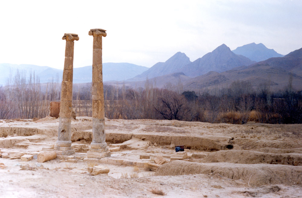
Fig. 1. The general view of the colonnaded façade with the standing columns with their Ionic capitals in 2006 (photo: Ali Mousavi)
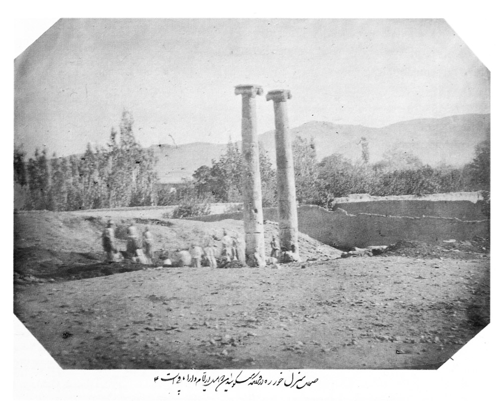
Fig. 2. The 1859 excavations at Khorheh. The original caption reads: “These columns are said to date back to the time of Dārā [Darius].” Albumen print, yellow-brown colored, 234 x 171mm, conserved in the Golestan Palace Library (photo: Ch. Adle, published in “Khorheh. The Dawn of Iranian Scientific Archaeology,” Tavoos Quarterly, Nos. 3&4, Spring & Summer 2000, p. 27 of the English text)
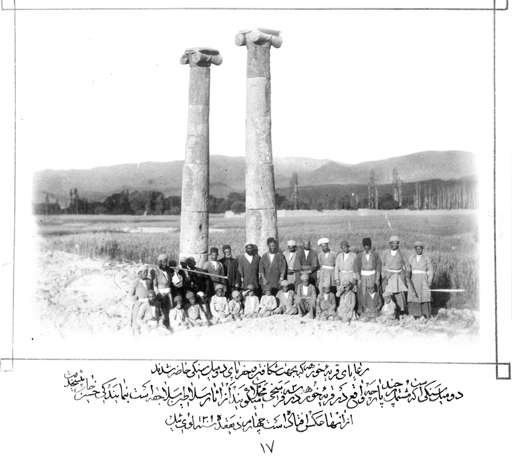
Fig. 3. The 1892 excavations as shown on this photograph with a caption that reads: “Panorama of the village of Khorheh and the two columns mentioned,” dated to the 4th of Zi-qa‘deh in the year 1309, Lūy-ïl / 31 May 1892. Glass plate, 179 x h. 128 mm., conserved in the Golestan Palace Library (photo: Ch. Adle, published in “Khorheh. The Dawn of Iranian Scientific Archaeology,” Tavoos Quarterly, Nos. 3&4, Spring & Summer 2000, p. 22 of the English text)
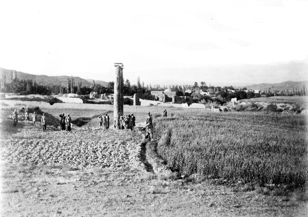
Fig. 4. The 1892 excavation of the colonnaded building, dated to the 4th of Zi-qa‘deh in the year 1309, Luy-yil / 31 May 1892. Glass plate, 179 x h. 128 mm., conserved in the Golestan Palace Library (photo: Ch. Adle, published in “Khorheh. The Dawn of Iranian Scientific Archaeology,” Tavoos Quarterly, Nos. 3&4, Spring & Summer 2000, p. 25 of the English text)
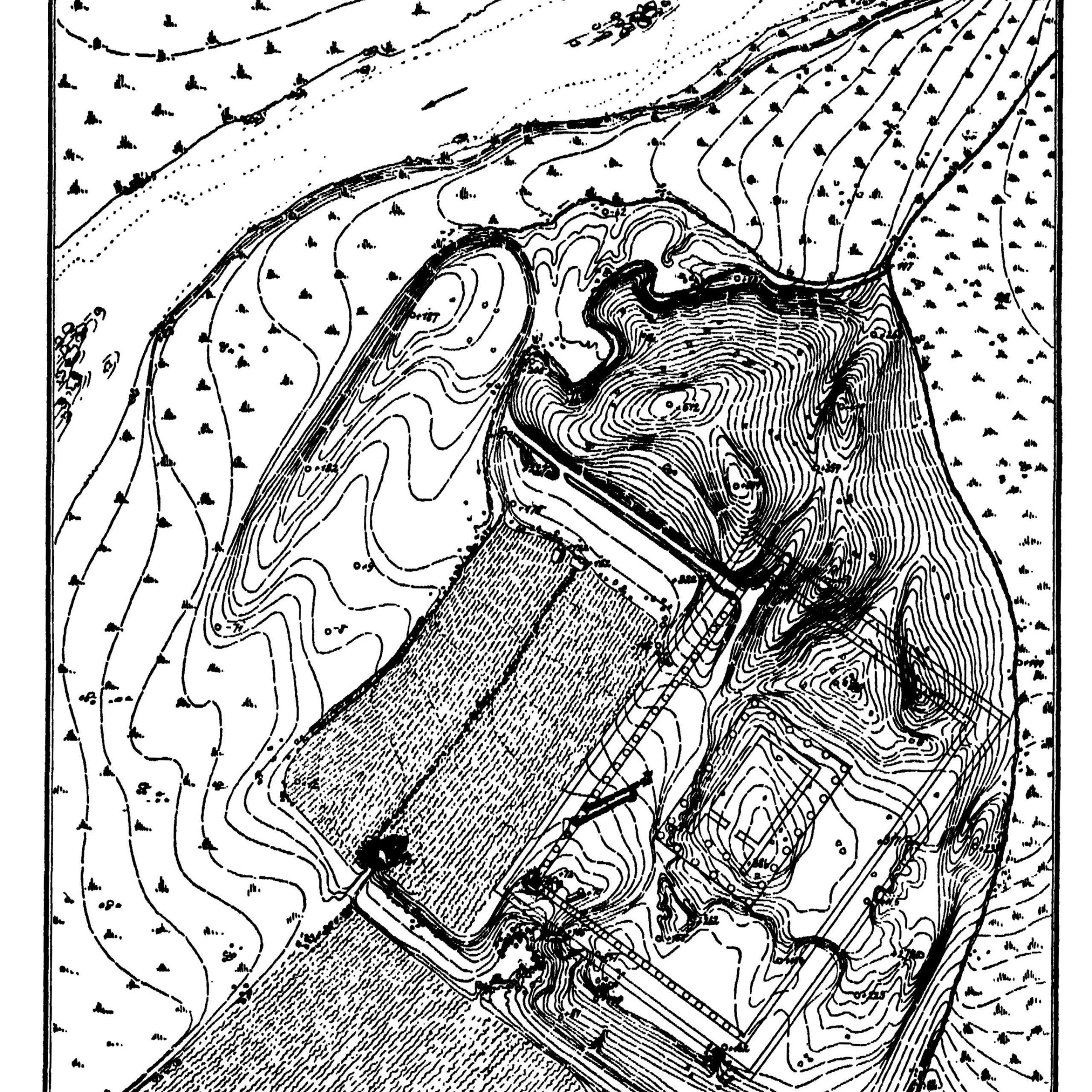
Fig. 5. The general plan of the site drawn by Ernst Herzfeld (after Herzfeld, Iran in the Ancient East, p. 283, fig. 382)
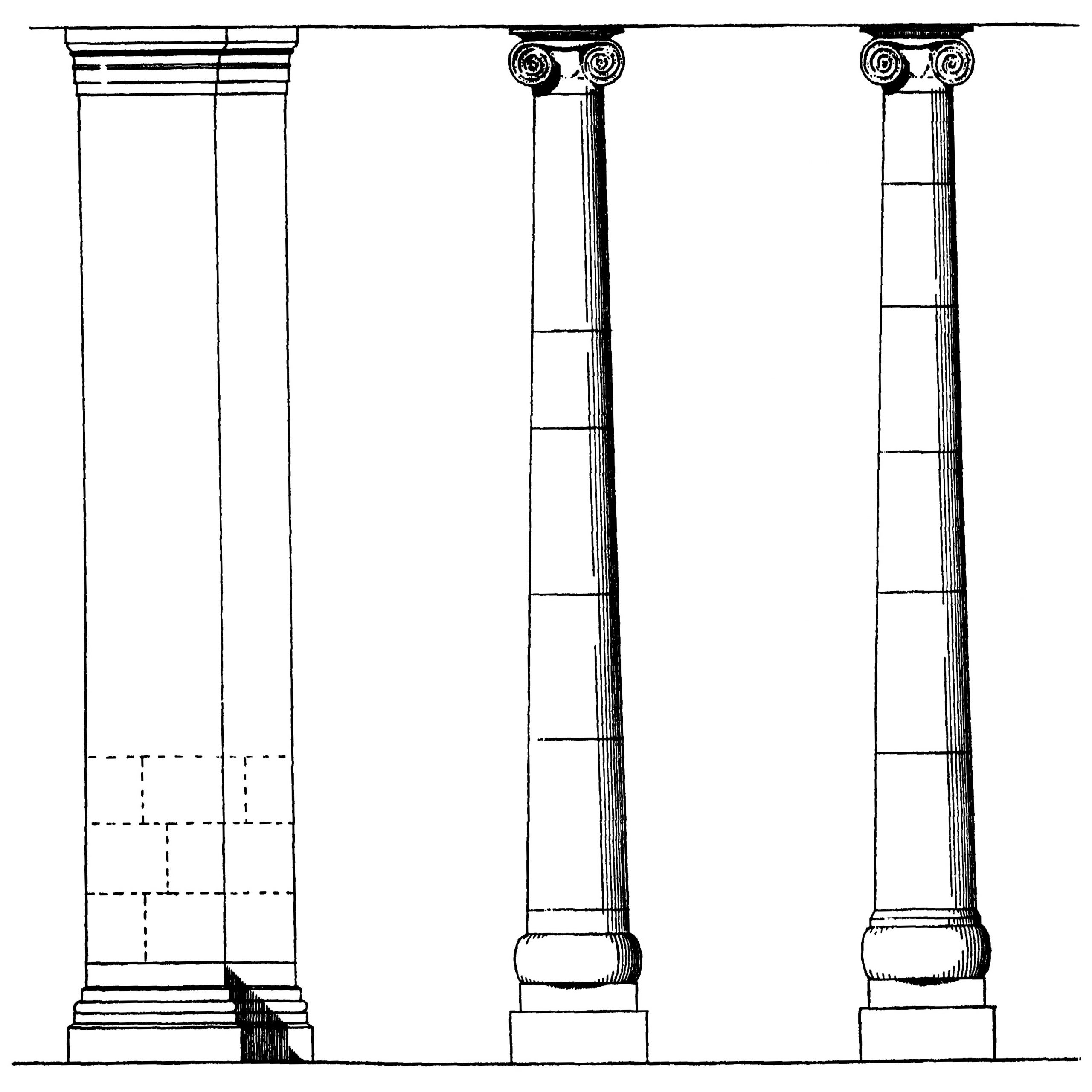
Fig. 6. Reconstruction of the standing columns by Ernst Herzfeld (Herzfeld, Iran in the Ancient East, p. 284, fig. 383)
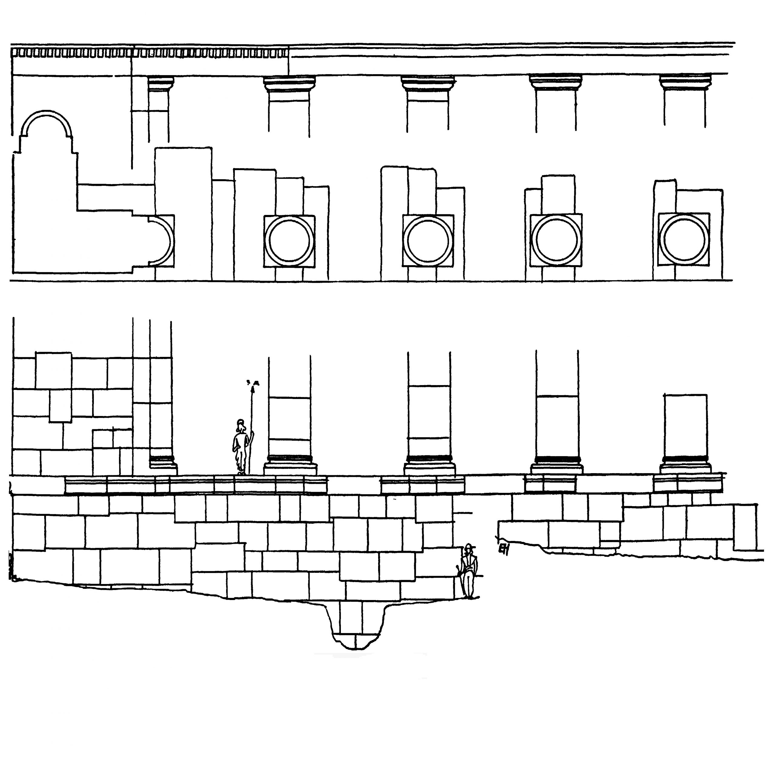
Fig. 7. Herzfeld’s reconstruction of the colonnaded façade (Herzfeld, Iran in the Ancient East, p. 282, fig. 380)
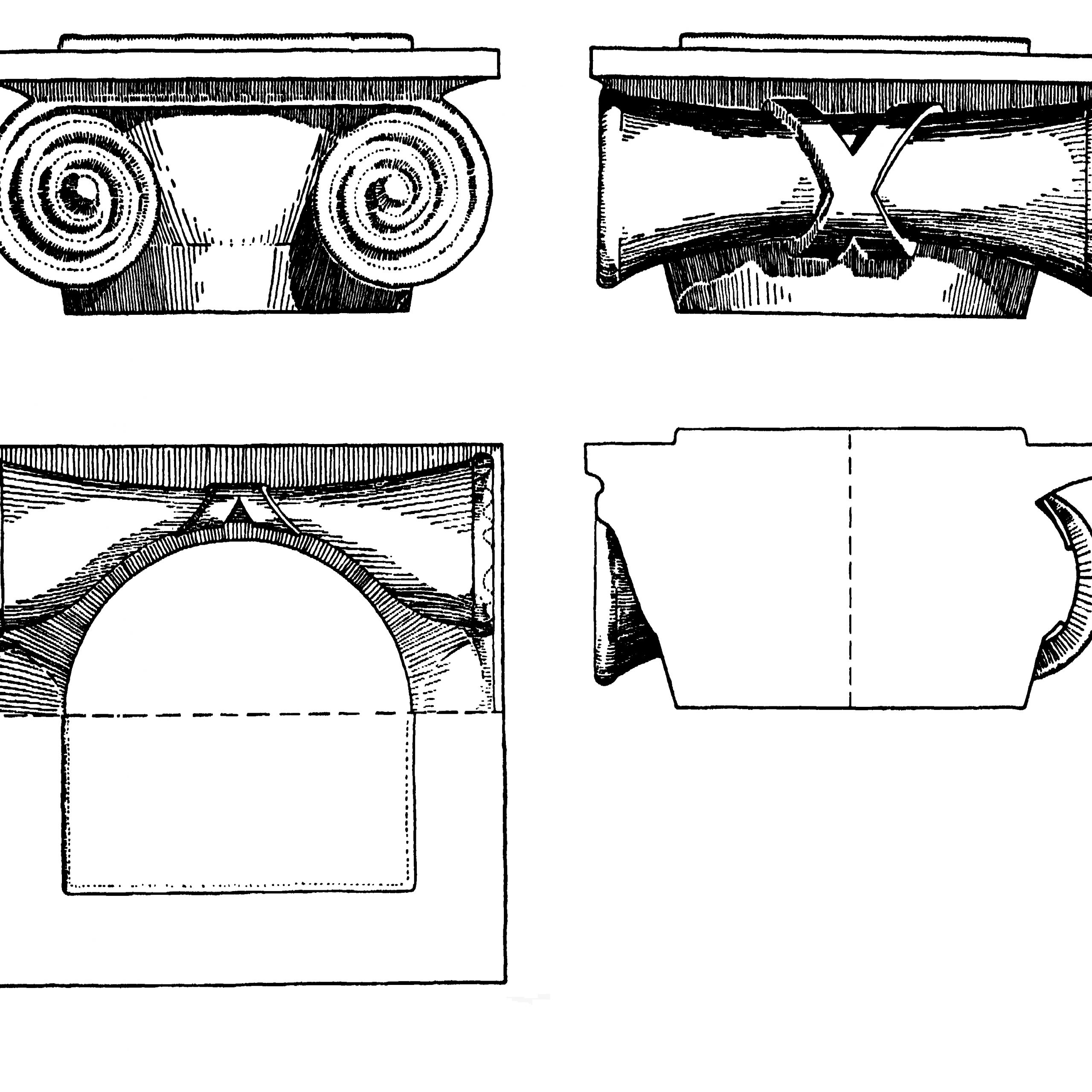
Fig. 8. Herzfeld’s drawing of the Ionian capitals at Khorheh (Herzfeld, Iran in the Ancient East, p. 285, fig. 385)
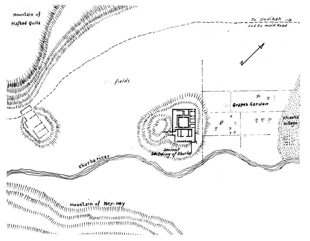
Fig. 9. Hakemi’s topographic map of the site in 1955 (Hakemi, “The Excavation of Khurha,” East and West 40/1, 1990, p. 18, fig. 6)
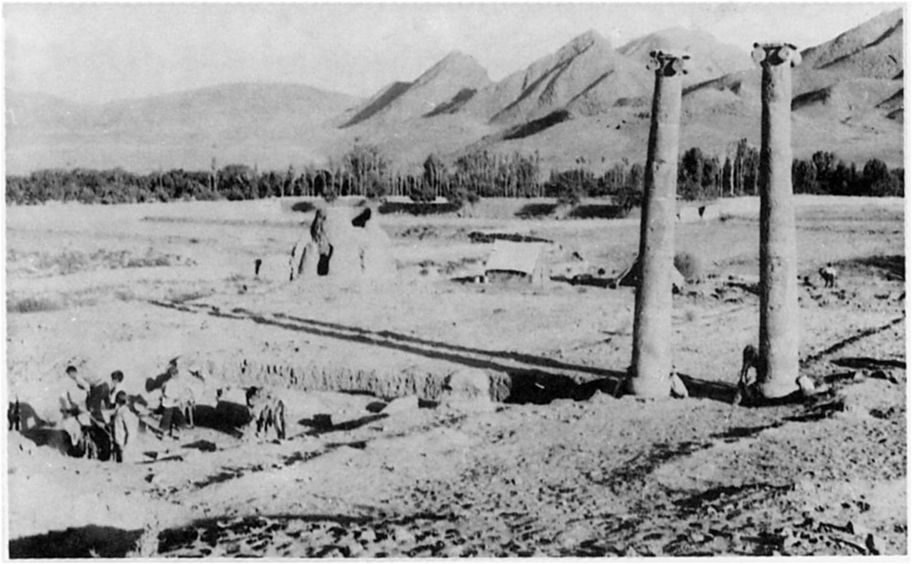
Fig. 10. Hakemi’s excavations in 1955. In the background, left, is the village’s lime kiln on the southwestern edge of the Parthian building. Lime and brick kilns have been a major threat to ancient mud-brick structures throughout the country (Hakemi, “The Excavation of Khurha,” East and West 40/1, 1990, p. 27, fig. 15)
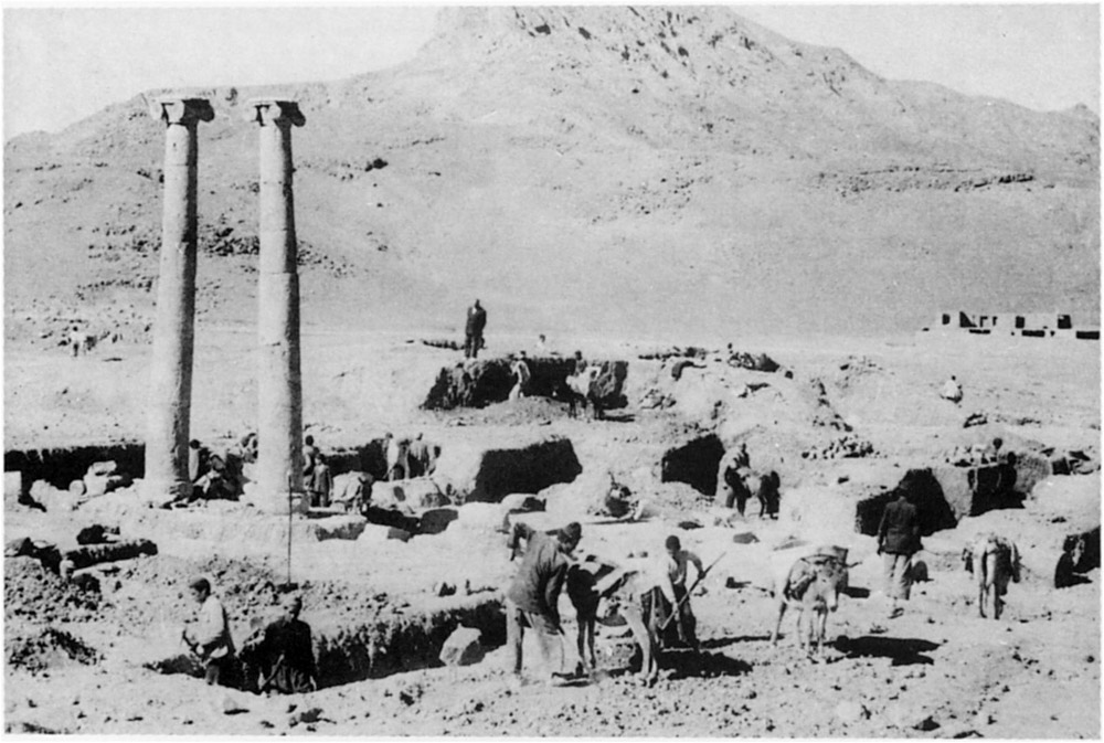
Fig. 11. Hakemi’s excavation of the main building and its walls in 1955 (Hakemi, “The Excavation of Khurha,” East and West 40/1, 1990, p. 31, fig. 19)
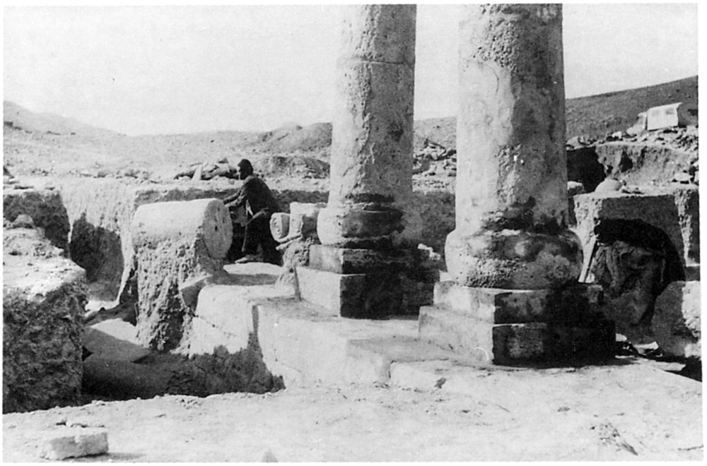
Fig. 12. Hakemi’s excavation in 1955. Column bases restored with cement. (Hakemi, “The Excavation of Khurha,” East and West 40/1, 1990, p. 27, fig. 16)
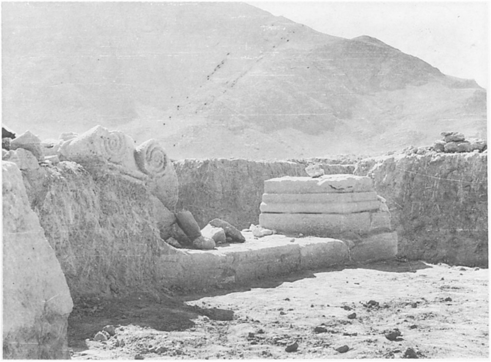
Fig. 13. Hakemi’s excavations in 1955. Excavation of the colonnade. A pilaster base and a capital with volute are visible (Hakemi, “The Excavation of Khurha,” East and West 40/1, 1990, p. 26, fig. 14)
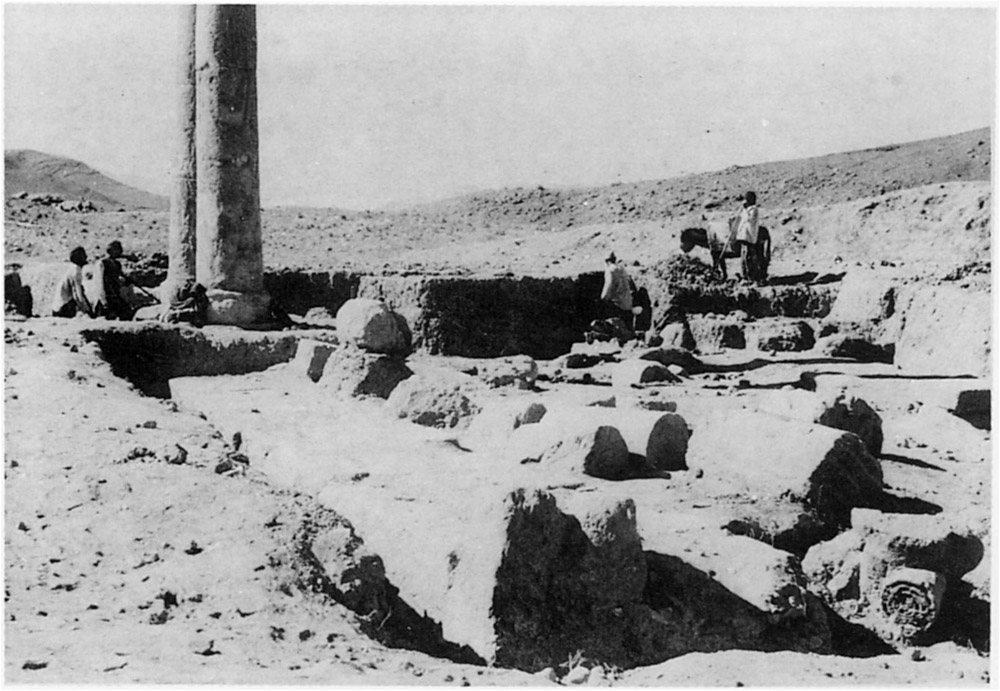
Fig. 14. Hakemi’s excavations in 1955. Excavation of the rooms adjacent to the colonnade (Hakemi, “The Excavation of Khurha,” East and West 40/1, 1990, p. 32, fig. 20)
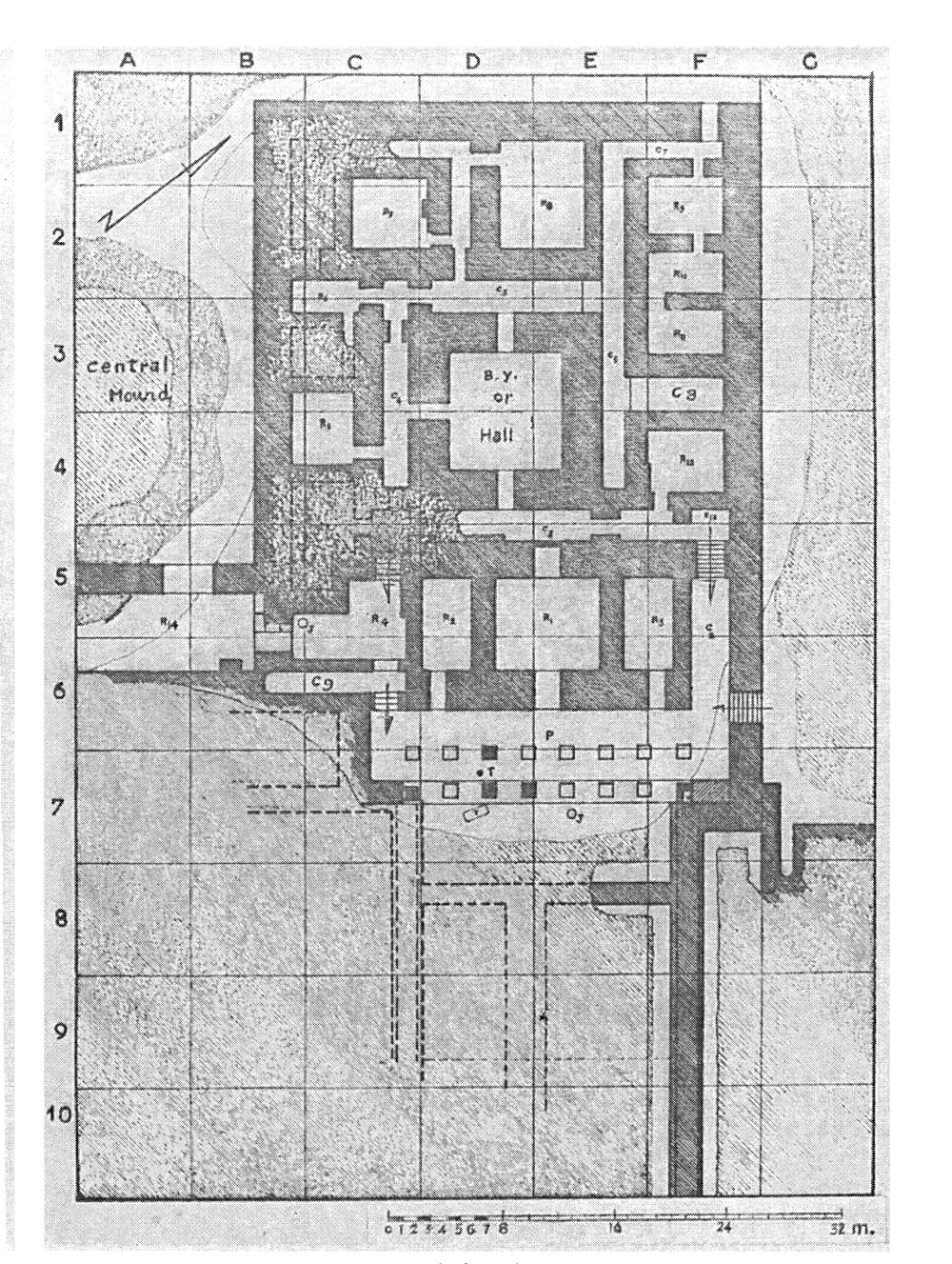
Fig. 15. Hakemi’s excavations in 1955. Plan of the main building with a colonnade (Hakemi, “The Excavation of Khurha,” East and West 40/1, 1990, p. 20, fig. 9)
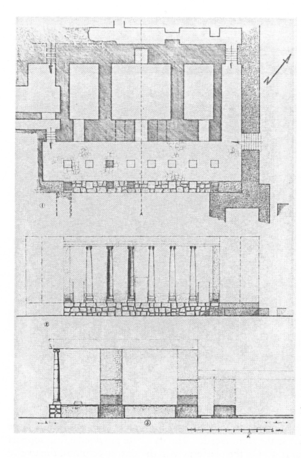
Fig. 16. Hakemi’s excavations in 1955. Plan of the main building with a colonnade (Hakemi, “The Excavation of Khurha,” East and West 40/1, 1990, p. 22, fig. 11)
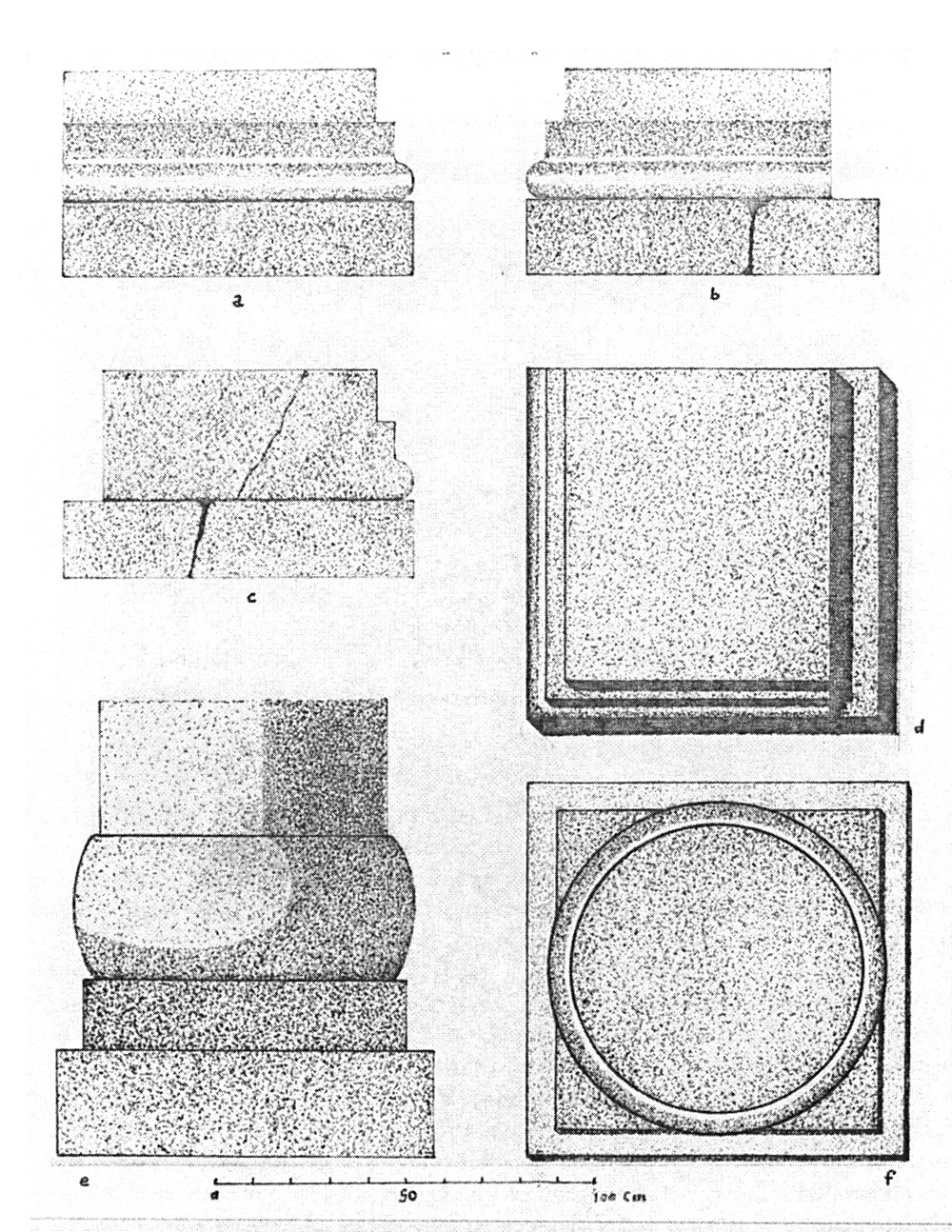
Fig. 17. Hakemi’s excavations in 1955. Base and pilaster (Hakemi, “The Excavation of Khurha,” East and West 40/1, 1990, p. 25, fig. 13)
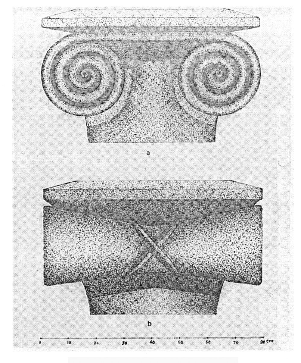
Fig. 18. Hakemi’s excavations in 1955. Front and side views of the capitals (Hakemi, “The Excavation of Khurha,” East and West 40/1, 1990, p. 28, fig. 17)
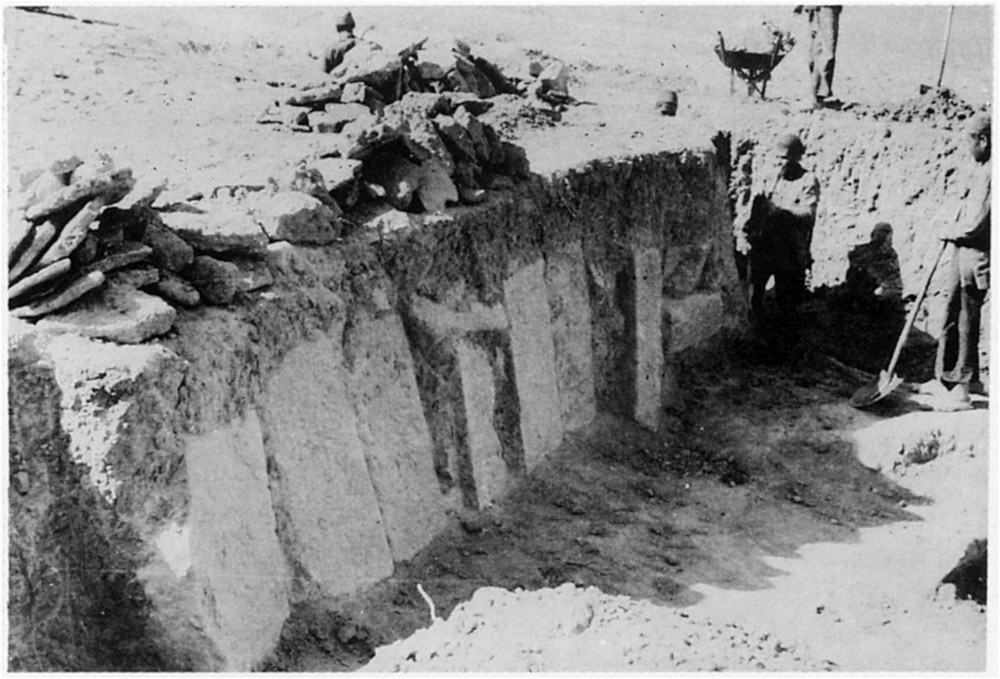
Fig. 19. Hakemi’s excavations in 1955. The passageway connecting rooms 4 and 14 with upright stones. Hakemi reports that the upright position of stones is the result of later human destruction or secondary use of the rooms (Hakemi, “The Excavation of Khurha,” East and West 40/1, 1990, p. 33, fig. 22)
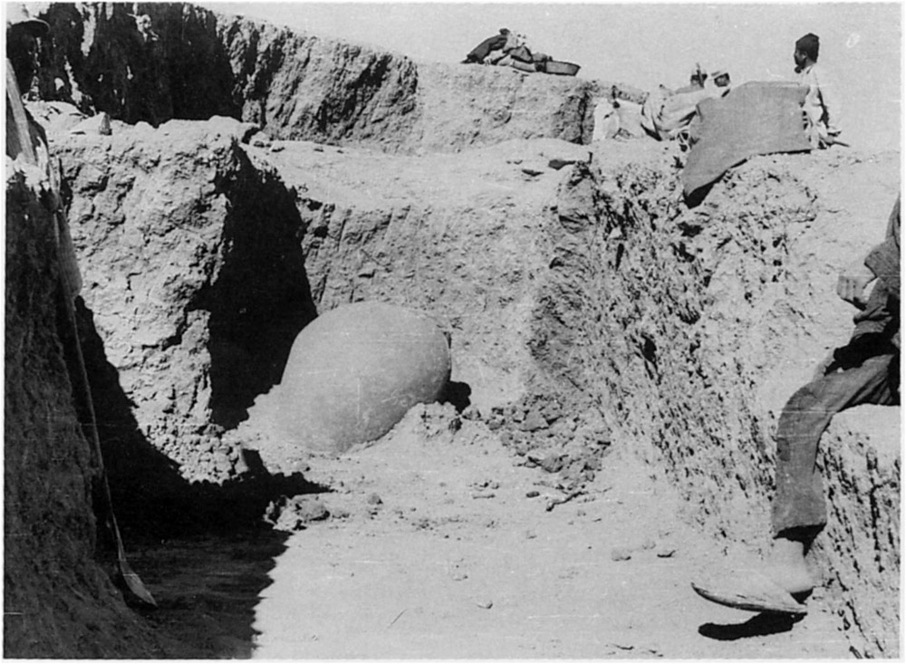
Fig. 20. Hakemi’s excavations in 1955. Room with storage jar (Hakemi, “The Excavation of Khurha,” East and West 40/1, 1990, p. 36, fig. 25)
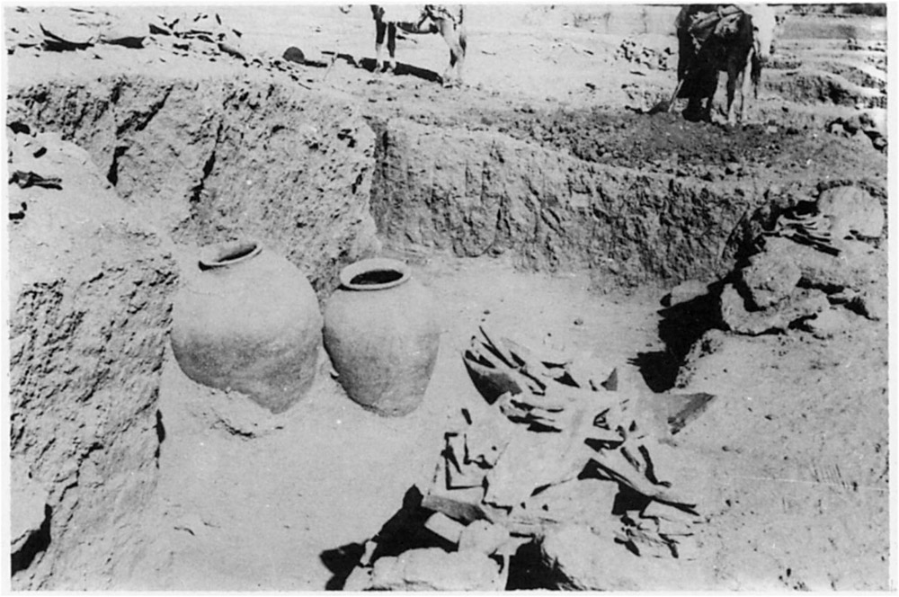
Fig. 21. Hakemi’s excavations in 1955. Room with storage jars (Hakemi, “The Excavation of Khurha,” East and West 40/1, 1990, p. 37, fig. 26)
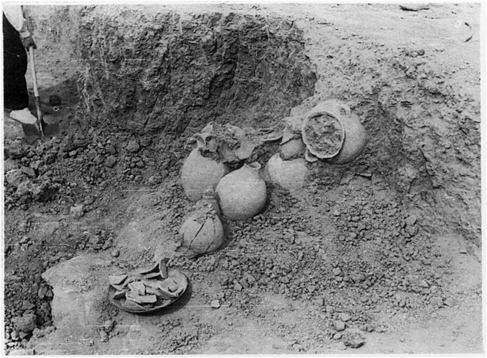
Fig. 22. Hakemi’s excavations in 1955. Room with storage jars (Hakemi, “The Excavation of Khurha,” East and West 40/1, 1990, p. 37, fig. 27)
Fig. 23. Hakemi’s excavations in 1955. Discovery of a buff jar and its lid containing an equid burial. (Hakemi, “The excavation of Khurha,” East and West 40/1, 1990, p. 38, fig. 28)
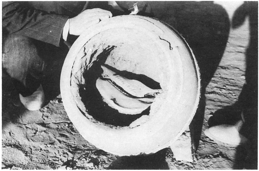
Fig. 24. Hakemi’s excavations in 1955. Skull of an equid found inside the jar. Equid burials in the Parthian period are rare. (Hakemi, “The excavation of Khurha,” East and West 40/1, 1990, p. 38, fig. 28)
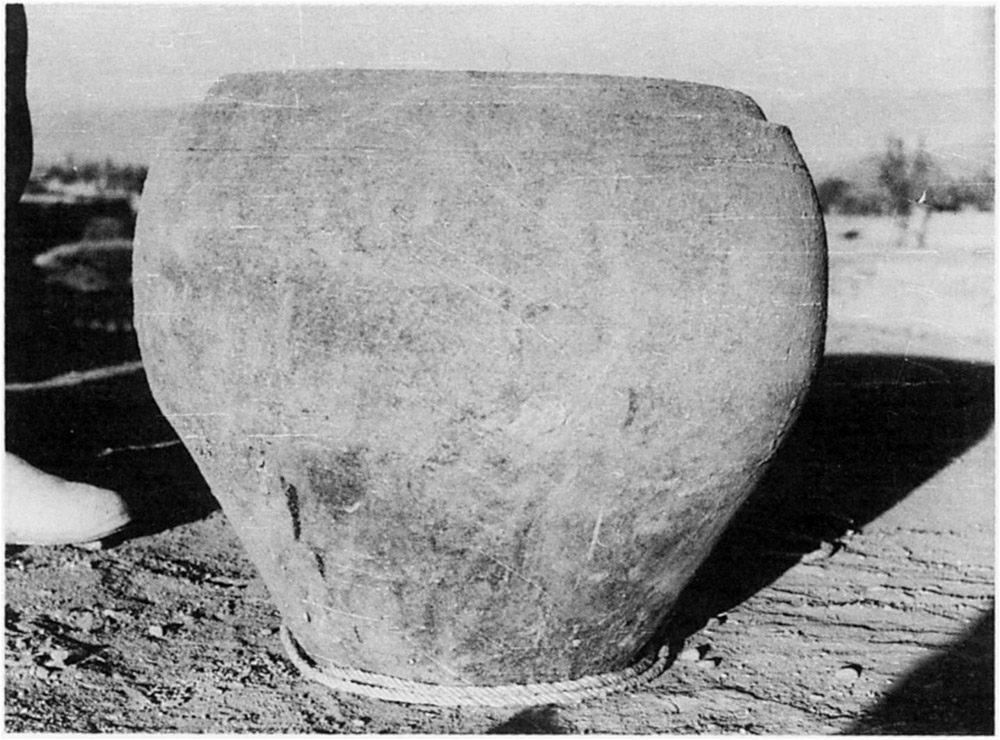
Fig. 25. Hakemi’s excavations in 1955. The jar containing an equid burial. (Hakemi, “The excavation of Khurha,” East and West 40/1, 1990, p. 39, fig. 30)
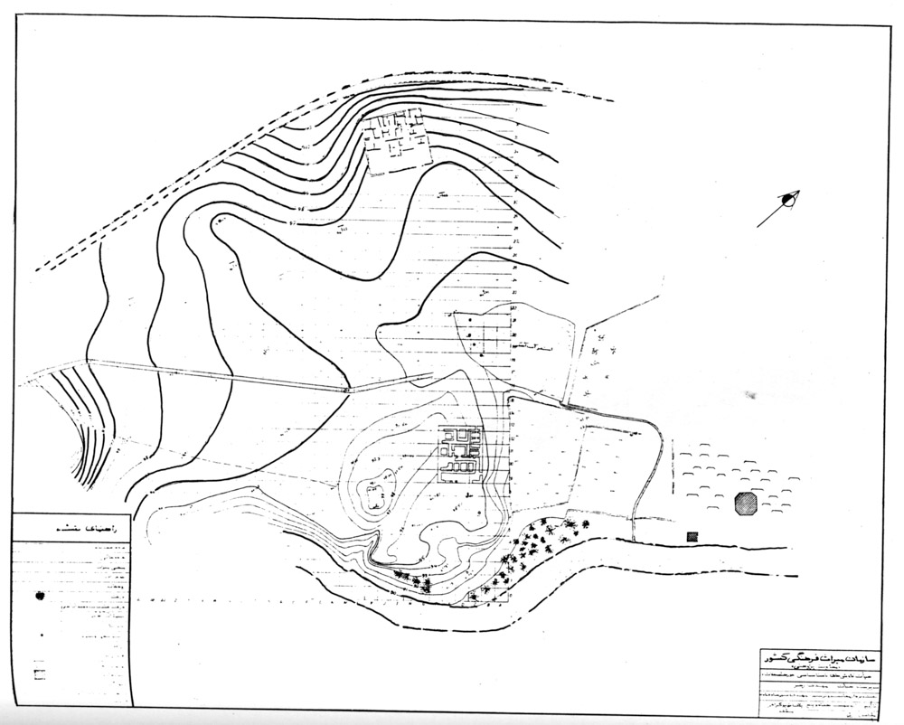
Fig. 26. Topographic plan of the site with the excavated areas (Rahbar, M., Kāvoshhāy-e bāstānshenāsi-ye Khorheh, Tehran, 1382 H.S./2003)
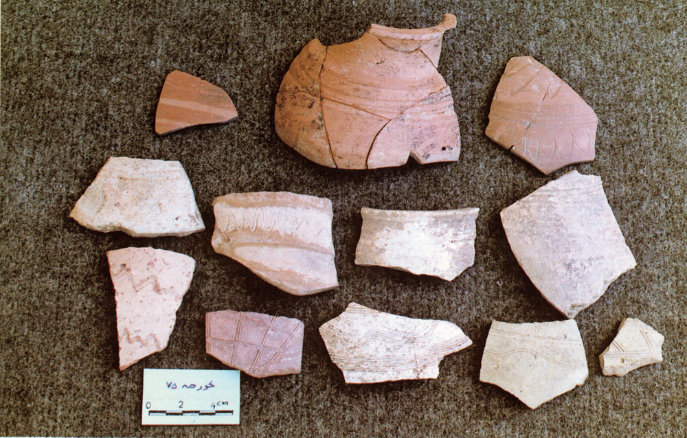
Fig. 27. A collection of Parthian ceramics. Photography by Mehdi Rahbar (Adle, “Khorheh. The dawn of Iranian scientific archaeology,” Tavoos Quarterly, Nos. 3&4, Spring & Summer 2000, p. 32 of the English text)
Finds:
Architectural remains in stone and mud-brick; Clinky Ware of the Parthian period.
Bibliography:
Adle, Ch., “Khorheh. The Dawn of Iranian Scientific Archaeology,” Tavoos Quarterly, Nos. 3 and 4, spring and summer 2000, pp. 4-29 (English text), pp. 226-239 (Persian text). Available at:
http://www.tavoosonline.com/Articles/ArticleDetailFa.aspx?src=130&Page=1
Ala’i Moghaddam, J., and L. Bani Jamali, “Fa’ālliyathāy-e bāstānshenāsiy-e Mahallāt,” Eighty Years of Iranian Archaeology, vol. 1, Y. Hassanzadeh and S. Miri (eds.), National Museum of Iran, Tehran, 2012, pp. 172-177, 171-184.
Feuvrier, J.-B., Trois ans à la cour de Perse, Paris, n.d.
Haerinck, E., La céramique en Iran pendant la période parthe (ca. 250 av. J.C. à ca. 225 après J.C.), Ghent, 1983.
Hakemi, A., “The Excavation of Khurha,” East and West 40/1, 1990, pp. 11-41.
Herzfeld, E., Am Tor von Asien, Berlin, 1920.
Herzfeld, E., “Reisebericht,” Zeitschrift der Deutschen Morgenländischen Gesellschaft, 1926, pp. 225-284.
Herzfeld, E., Archaeological History of Iran, London, 1934, pp. 50-51, pl. VI.
Herzfeld’s photographs and papers on Khorheh
http://collections.si.edu/search/results.htm?view=grid&dsort=&date.slider=&q=Ernst+Herzfeld+Khurha
Houtum-Schindler, A., Eastern Persian Irak, London, 1897.
Kleiss, W., “Qal’eh Zohak in Azerbaidjan,” Archaeologische Mitteilungen aus Iran 6, 1973, pp. 174-181.
Kleiss, W., “Bemerkungen zum Säulenbau von Khurha,” Archaeologische Mitteilungen aus Iran 14, 1981, pp. 65-67.
Kleiss, W., “Die Säulenbau von Khurha,” Archaeologische Mitteilungen aus Iran 18, 1985, pp. 173-179.
Kleiss, W., “Beobachtungen in der Umgebung Dodehak,” Archaeologische Mitteilungen aus Iran 27, 1994, pp. 205-221.
Meshkati, N., 1970, A List of Historical Sites and Ancient Monuments of Iran, Tehran, 1970.
Qomi, H., Tārikh-e Qom, edited by Seyyed Jalāl Tehrāni, Tehran, 1361 H.S./1982, pp. 73-74.
Rahbar, M., “Khorheh. Une résidence parthe sur le Plateau iranien,” Dossiers d’Archéologie, No. 243, mai 1999, pp. 44-46.
Rahbar, M., Kāvoshhāy-e bāstānshenāsi-ye Khorheh, Tehran, 1382 H.S./2003.
Saurat, A., Exposition des dernières découvertes archéologiques 1973-1974, Musée Iran Bastan, Centre Iranien de Recherches Archéologiques, Tehran, 1974.
Schippmann, K., Die Iranischen Feuerheiligtümer, Berlin, 1971, pp. 424-430.
 DOWNLOAD AS PDF


