Alamūtالموت
Location: The fortress of Alamūt is located in the mountains of central northern Iran, Qazvin Province.
36°26’39.6″N 50°35’10.5″E
Map
Historical Period
Islamic
History and description
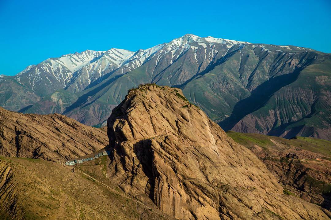
The Alamūt Castle, better known as Hasan Sabbah’s Castle, overlooks the Gāzurkhān village and its surrounding valley (fig. 1). Access to Alamūt has been challenging due to its narrow gorges and surrounding mountains. The original route was a two-day mule journey from Qazvīn. In the 1960s, an automobile track was built along this trail, but it was later replaced by a modern road further west. The castle, taking the shape of an elongated stronghold, sits on a single, steep-sided ridge in the southern foothills of the central Albōrz Mountains. The ridge stands 220 meters above the surrounding terrain, perched on a sheer precipice and encircled by deep, winding, and treacherous gorges. As Jōveyni puts it, “Alamūt is a mountain that resembles a kneeling camel with its neck laid on the ground.” Ibn Athir, the prolific thirteenth-century historian, recounts a legend in which a ruler of Deylam, who was passionate about hunting, frequently visited the hunting grounds. One day, after releasing his eagle, he followed its flight and saw it land on the spot where the castle now stands. He found the location to be very strong and well-fortified, so he ordered a fortress to be built on the heights. He named it Alamut, which in the Daylami language means “the place that the eagle showed”. Hence the name Eagle’s Nest that has since been associated with that farsighted stronghold of the Isma’ilis.
According to Hamd-Allah Mostowfi in his Tarikh-e Gōzida the first castle was built in 240 H./860 by Hasan ibn Zeyd Bāgheri, an Alīd Shī’it who rose against the Abbasid caliph in Tabarestan in northern Iran. Later in 483 H./1090, Hasan Sabbah gained possession of the castle and made it a major base in his rising against the Saljuq rulers of Iran. Hasan, the founder of the Nizari branch of Isma’ilism in Persia—better known as the Assassins—refortified and enlarged the original castle by adding water reservoirs and farmlands at the foot of the mountain. The Nizari Isma’ilis ruled over the area for 171 years. Hülegü the mighty Ilkhān of Persia captured the castle in 673 H./1275.
During the assault on the Ismaili fortresses at the time of Hülegü, Atā-Malik Jōvayni, who was accompanying the Ilkhān, drew his attention to the importance of the castle’s library and requested Hülegü’s permission to examine it before the castle was burned and destroyed. Hülegü agreed, and Atā-Malik visited the library, preserved some books, and unfortunately burned others that he deemed to contain heretical material. During this visit, he also took with him several important astronomical instruments. Among the books was the biography of Hasan Sabbah, known as the Sargozasht-e Seyyed-e nā, which he fortunately preserved. In fact, Rokn-al-Din, the Islam’īlī commander of the castle at the time of the Mongol assault, declared his allegiance to the Ilkhān and simply tore down some gates and battlements.
There are occasional references to Alamūt Castle after the Ilkhānid period; however, its importance steadily declined. By the reign of Shah Ṭahmāsp in the sixteenth century, the fortress had been reduced to use as a prison, reflecting its diminished strategic and political significance. By the nineteenth century, the site appears to have fallen into ruin, eventually becoming the target of looting by antiquities hunters. One of the Qajar princes, Abd al-Samad Mirza Ezz’al-Dowla, the governor of Qazvin, employed hundreds of workers to dig up antiquities within the castle’s ruined structures.
The Alamut Castle, which includes both the upper and lower sections, is a massive structure built atop a rocky cliff. Its four surrounding walls were constructed to follow the natural shape and formation of the rock, which is why their width varies in different parts. The built area of the castle is 120 m long and 10 to 35 m wide. Of the castle’s towers, three remain standing at the northern, southern, and eastern corners, with the eastern corner tower being the best preserved. The gate and only entrance to the castle are located at the end of the northeastern side. The entrance path leading to the gate begins at the base of the eastern tower and is situated a few meters below it. At this point, a tunnel has been carved into the rock parallel to the southeastern side of the castle, measuring 6 meters in length, 2 meters in width, and 2 meters in height. Upon passing through this tunnel, the southern tower and the southwestern wall of the castle, constructed along the slope of a rocky surface, come into view.
The materials used in different parts of the castle include stone, gypsum mortar, brick, tile, and terracotta pipes with a diameter of 10 centimeters. In the construction of the walls, wooden beams were placed horizontally inside the structure to reinforce the walls and to connect the front sections of the towers to the rear sections. Among the small tile fragments found in the ruins of the castle, one piece is sky blue and depicts a human face, with parts of the eye, eyebrow, and nose clearly visible. The castle had adjacent defensive structures, the ruins of which are now visible on the southern slope of Mount Hoodkan to the north of the castle. An adjacent graveyard to the west of the castle has been identified as the resting place of the castle’s inhabitants.
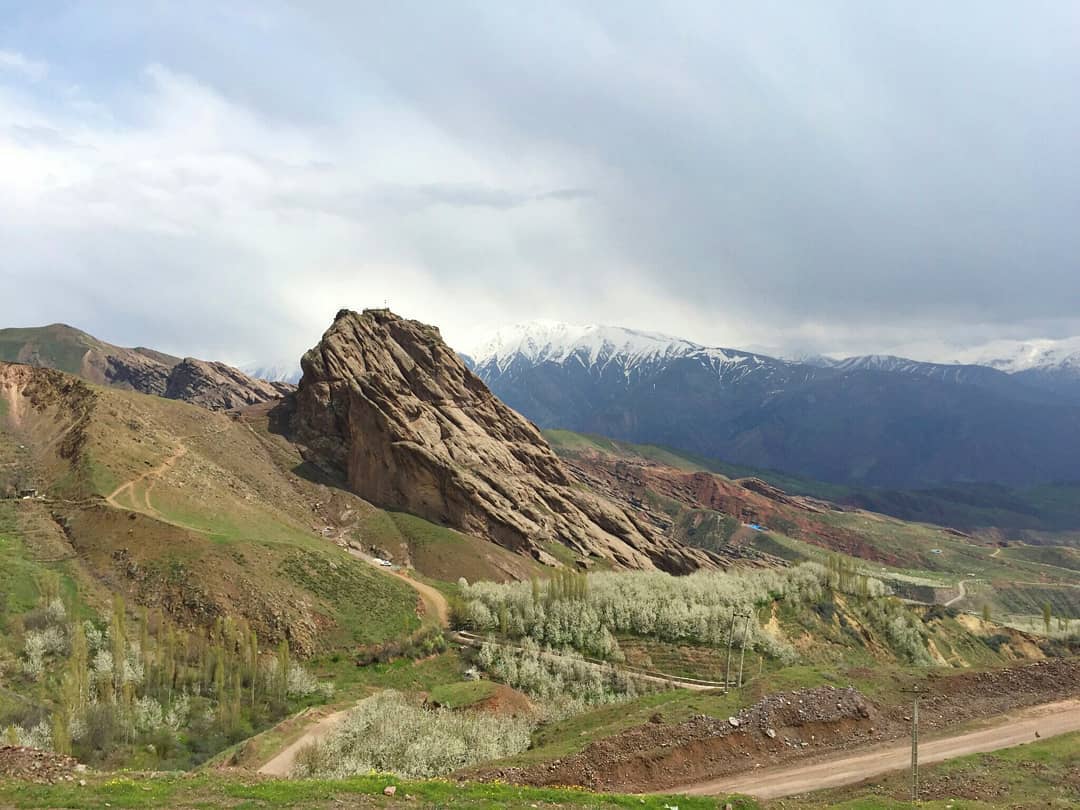
Fig. 1. The rock of Alamūt, on top of which lies the ruined castle (image: CreativeCommons)
Archaeological Exploration
Despite its fame, Alamūt was rarely visited by Western travelers before the twentieth century, although it was frequently mentioned in their accounts, most notably by Marco Polo, who never visited the ruined castle. The earliest, and quite misleading, paper known to me was that by Colonel William Monteith, who passed through these localities in 1831. The earliest detailed description was written by another British officer, Justus Shiel, who visited the site in the spring of 1837. Due to its difficult access, the site remained largely unexplored until the 1930s. In 1931, Freya Stark, the British traveler and writer, climbed up to Alamūt Castle and published a romantic account of her visit. In the same year, the Russian Orientalist Vladimir Ivanow visited the ruined castle in 1928 and 1931. In 1957–58, building on his earlier investigations from 1928 and 1937, Ivanow carried out hasty excavations in the ruins. Yet, his investigations resulted in what remains the most comprehensive monograph on the subject Alamut and Lamasar, accompanied by the first excellent photographs taken by Laurence Lockhart. In the 1950s, Manūchehr Sotudeh, a Professor of History at the University of Tehran and a distinguished Iranian historian and geographer, traveled to the Alamūt region to study the medieval Ismaʿili fortresses. His Persian-language monograph Qōlāʿ-i Ismāʿīlīyah dar Rishtah-i Kūh’hā-ye Alborz—a detailed study of the Ismaʿili castles in the Alborz mountains—remains one of the most authoritative works on the history and archaeology of these sites. The book served as the basis for a later publication by Parviz Varjāvand on Alamūt Castle. In 1961, the British archaeologist Peter Willey, surveyed Alamūt Castle and published a relatively accurate plan of the structures. Between 1965 and 2001 and 2013, the Cultural Heritage Organization of Iran sponsored a large restoration and excavation project led by Hamideh Chubak.
Finds
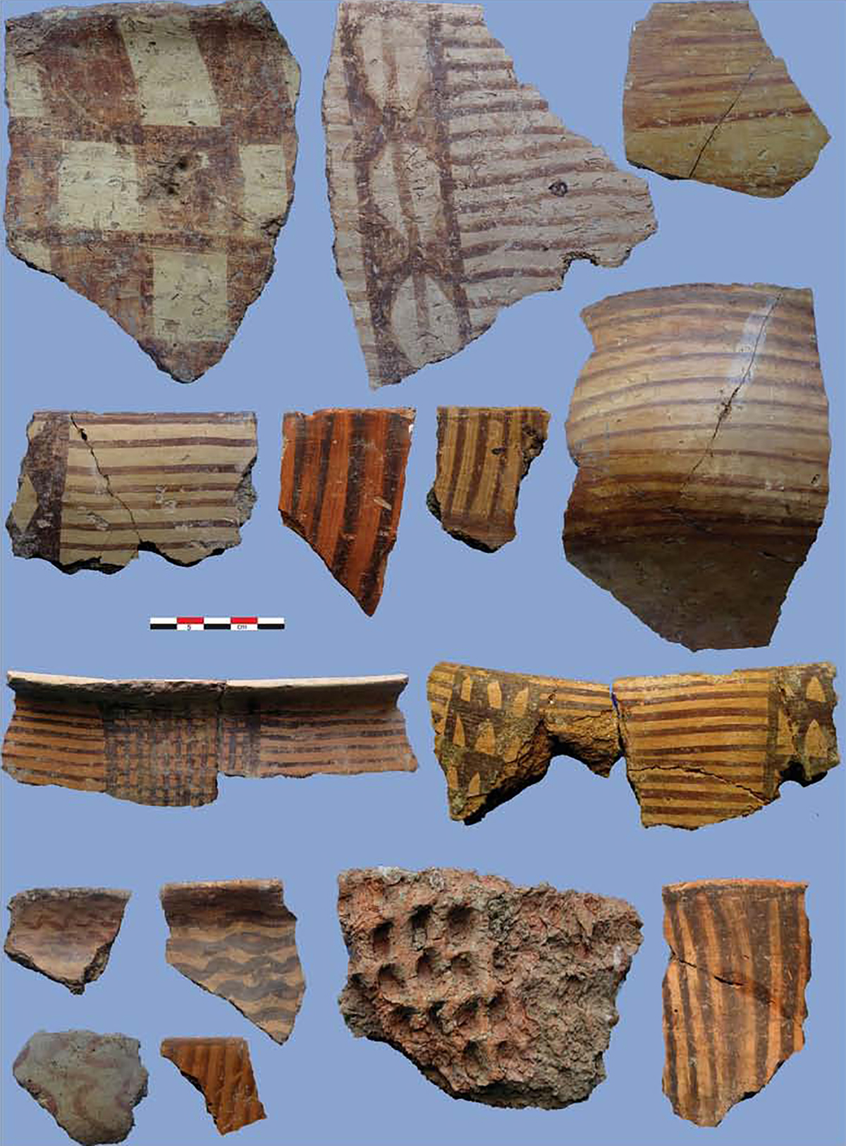
Excavated finds consist of typical glazed pottery of the Saljuq and Ilkhanid periods, plain pottery, and tools in iron or bronze.
Bibliography
Chūbak, Ḥ., “Kāvoshhā-ye bāstānshenākhtī dizh-i Ḥasan Ṣabbāḥ-e Alamūt’, Gozārishhā-ye Bāstānshenāsī, vol. 7, 1, Tehran, 1386/2007, pp. 85–130.
Hamd Allāh Mustawfī, Tārīkh-e Gōzīda, Tehran, 1380/2001, pp. 517-527.
Hourcade, B., “ALAMŪT, ” Encyclopaedia Iranica. Published December 15, 1985. https://www.iranicaonline.org/articles/alamut-valley-alborz-northeast-of-qazvin/
Monteith, W., “Journal of a Tour through Azerdbijan and the Shores of the Caspian,” Journal of the Royal Geographical Society, vol. 3, 1833, p. 15.
Lockhart, L., “Ḥasan-i Sabbāḥ and the Assassins”, Bulletin of the School of Oriental Studies, vol. 5, 1930, pp. 675-696.
Ivanow, V. A., “Almut,” The Geographical Journal, vol. 77, No. 1, 1931, pp. 38-45.
Ivanow, V. A., Alamut and Lamasar: Two Mediaeval Ismaili Strongholds in Iran. An Archaeological Study, Tehran, 1960.
Sajjadi, S. et. al., “Alamūt,” in W. Madelung and F. Daftary (eds.), Encyclopaedia Islamica Online. Brill. https://doi.org/10.1163/1875-9831_isla_COM_0248
Shiel, J., “Itinerary from Teheran to Alamut and Khurrem Abad in May, 1837,” Journal of the Royal Geographical Society, vol. 8, 1838, pp. 431–432.
Sotuda, M., Qōlāʿ-i Ismāʿīlīyah dar Rishtah-i Kūh’hā-ye Alborz, Tehran, 1345/1967. pp. 72-108.
Stark, F., “The Assassins’ Valley and the Salambar Pass,” The Geographical Journal, vol. 77, No. 1, 1931, pp. 48-60.
Stark, F., The Valleys of The Assassins, London, 1934.
Varjāvand, P., Sarzamīn-e Qazvīn, Tehran, 1349/1970.
Willey, P., The Castles of the Assassins, London, 1963.